Project #1: Environmental Science/Physics
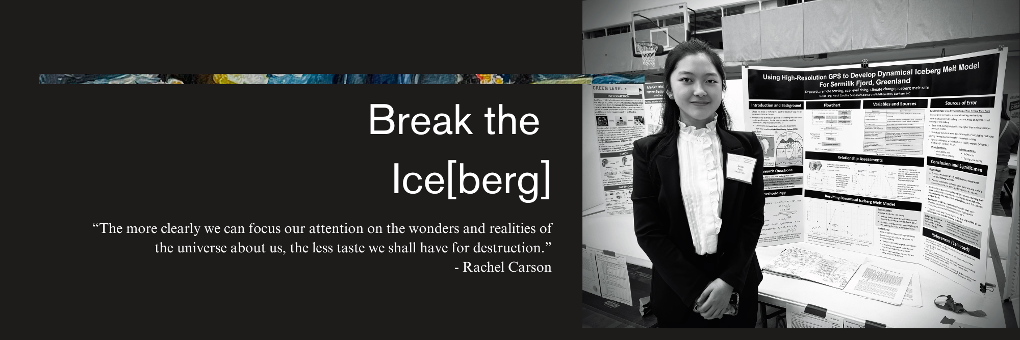
Using High-Resolution GPS to Develop Dynamical Iceberg Melt Model for Sermilik Fjord, Greenland
Student Researcher:
Teresa Fang
Mentor:
Michael Falvo
Abstract
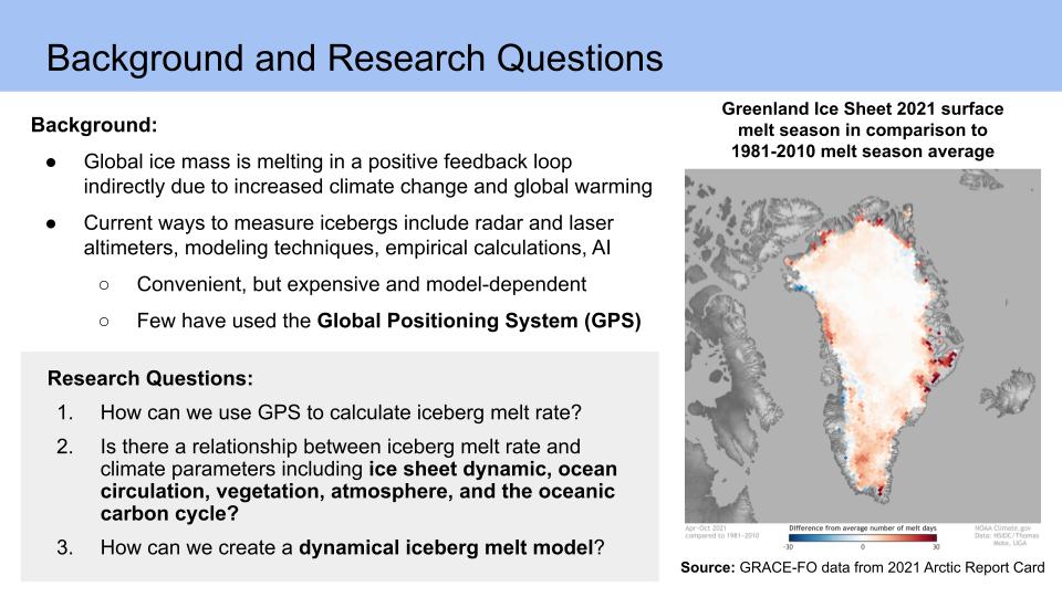
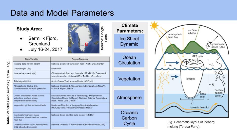
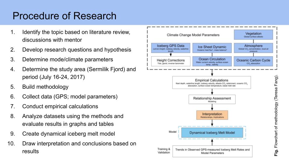
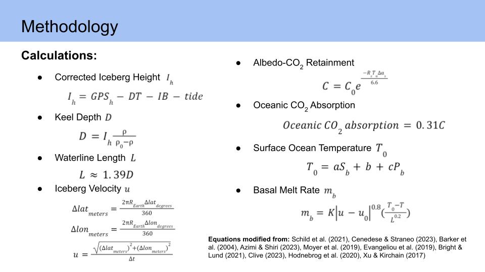
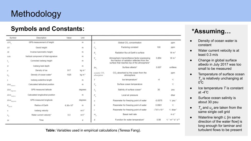
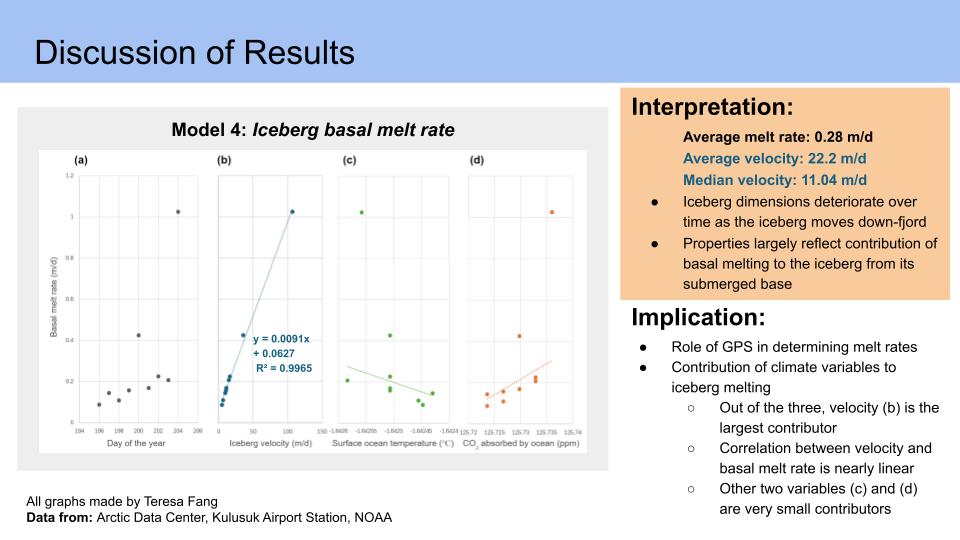
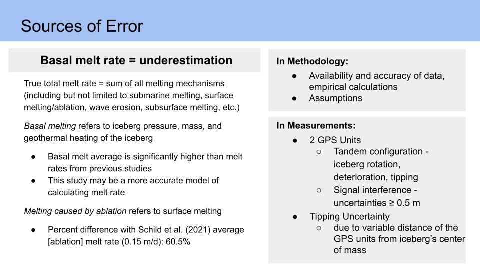
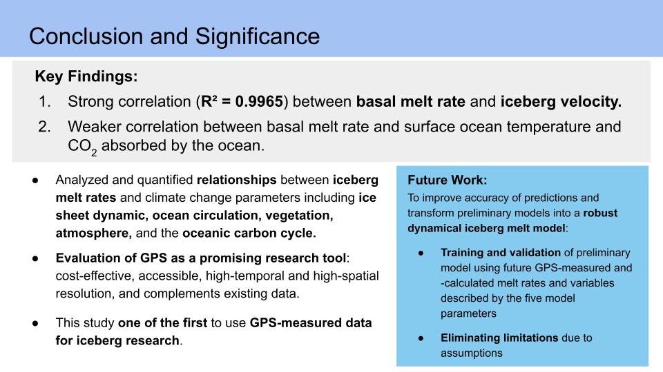
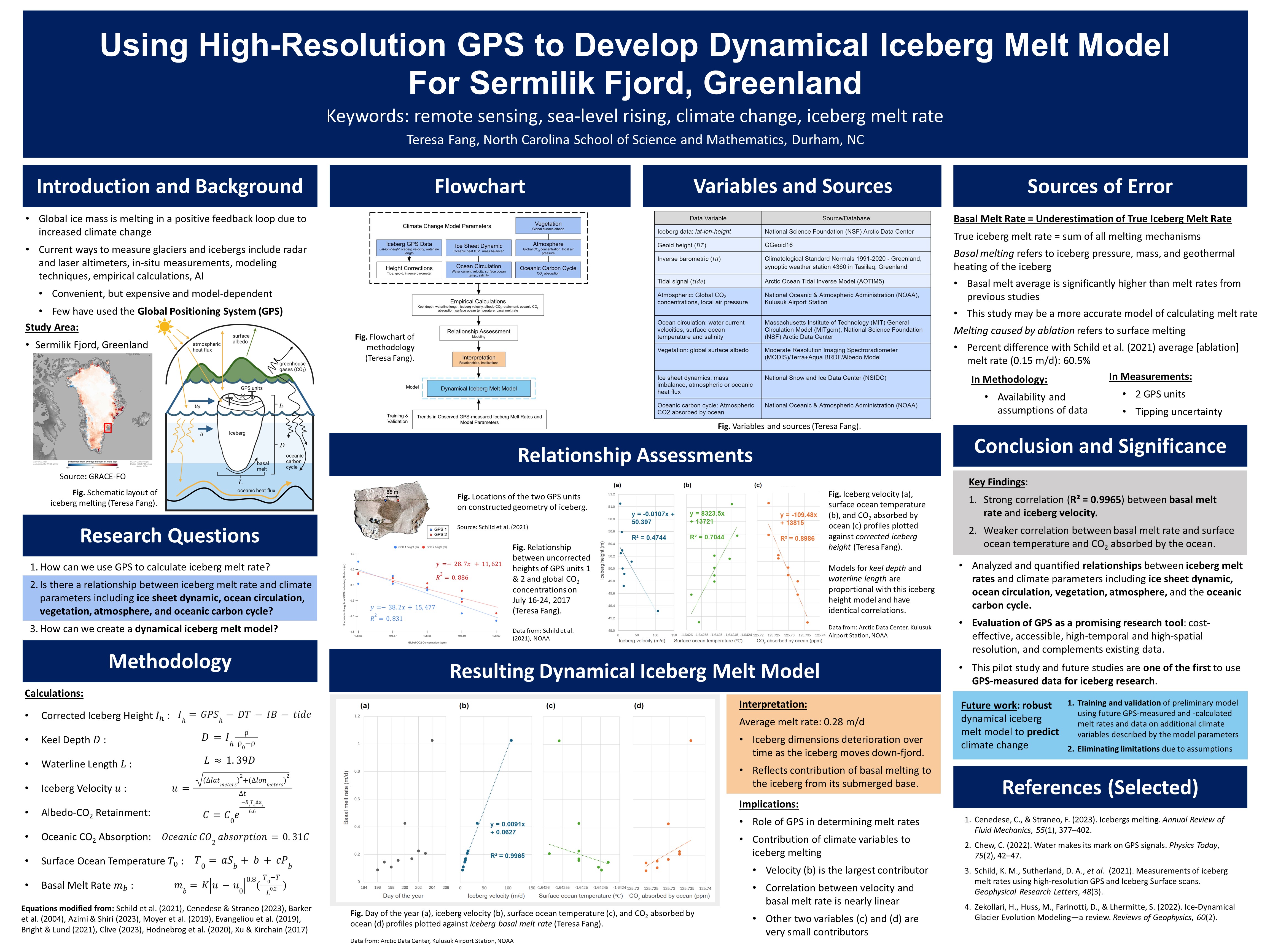
Despite the Global Positioning System’s (GPS) everyday popularity, there is another use of its signals: modeling iceberg dynamics. As airborne particles and surface albedo lead to heat fluxes trapped in the atmosphere, greenhouse gases like carbon dioxide are absorbed into the ocean, increasing the capacity of saltwater oceans to melt glaciers and icebergs in a positive feedback loop. Iceberg melting increases freshwater input to the subpolar North Atlantic and can cause sea-level rising, regional water imbalances, and water scarcity. Current iceberg studies have used remote sensing technologies including radar and laser altimeters, passive microwave satellite imagery, and computational models; however, these methods are often expensive and model-dependent. This pilot study presents a novel method to predict and model basal melt rates with five climate change parameters using high-temporal and -spatial resolution GPS data on an iceberg in the Sermilik Fjord, Greenland. Basal iceberg melt rates between 0.08 and 1.02 m/d were calculated over the 9-day survey, the largest contributing factor being iceberg velocity with a correlation of 0.9965. These basal melt rates are underestimations of true melt rates, due to assumptions of some variables and constants in empirical calculations and consideration of changes in the submerged iceberg portions. In creating a dynamical melt model using GPS measurements, GPS proves to be a promising tool for glaciology and climate research. In future work, this paper’s preliminary models will be trained and validated via future GPS measurements of melt rate into a more robust dynamical iceberg melt model.
Full paper not presented here.


Awards won:
- NOAA Taking The Pulse of the Planet Award (NCSEF 2024)
- Association of Women Geoscientists Excellence in Geoscience Award (NCSEF 2024)
- 2nd Place – Region 3B Science Fair: Environmental Science Category (NCSEF 2024)
- 1st Place in Environmental Science (NCSAS 2024)
Conferences presented at:
- 2024 Annual Biomedical Research Conference for Minoritized Scientists (ABRCMS) ePoster Spring Symposium for Emerging Scientists
- 2024 North Carolina Student Academy of Science (NCSAS)
- 2024 North Carolina Science and Engineering Fair (NCSEF)
Project #2: Immunology
Identification of MERS-CoV Antigenic Epitopes with MHC Class I and II Using Epitope Prediction Approach
Student Researchers:
Teresa Fang, Andrea Dela Pena
Project #3: Science Communication
Is it possible to use GPS to combat climate change?
Author:
Teresa Fang
Despite the Global Positioning System (GPS) being well known, few are aware of an alternative use of its signals. Aside from providing directions to the nearest café or restaurant, GPS can revolutionize remote sensing, serving as a tool to predict natural disasters and combat climate change.
GPS is a tool for remote sensing. At its core, remote sensing is communication through electromagnetism. It relies on two things: a transmitter and a receiver. A satellite’s transmitter will encode a message through various bands of electromagnetic frequencies using modulation, changing data into waves (Schauer). A receiver will then pick those up and transform the waves back into analytical data. Depending on factors like distance apart, size of antennas, types of electromagnetic transmission, bandwidth, or limiting power, different kinds of data can be measured and transmitted.
At present, GPS consists of a network of 31 broadcasting satellites orbiting Earth at an altitude of around 20,000 km. While normal radar satellites have both their receiver and transmitters on the satellites, GPS has receivers on the ground, listening and interpreting microwave satellite transmission. This means that at any point on the Earth’s surface, you are in the range of at least four satellites tracking the intersection of three physical dimensions, along with time, through trilateration. In an everyday example, your phone is the receiver to those four satellite transmitters to pinpoint your real-time location on Earth.
But what makes GPS an ideal tool to revolutionize remote sensing? After all, GPS is just a type of microwave radar system with a different scattering geometry than other systems, and microwave radar has been used for years to detect changes in Earth’s surface.
GPS reflectometry is one of the three techniques that have untapped potential for studying and combating climate change (Baier). The two others are occultation, which measures the vertical gradient of the atmospheric index (Eyre), and scatterometry, which scatters signals over targets like water to measure wind properties (COAPS). GPS signals are circularly polarized L-band signals (1-2 GHz range, at 19 or 24 cm specifically for GPS), which means they are unaffected by cloud cover and sunlight, thus making it easier to measure strong versus weak signals from surfaces with large changes in dielectric constants, such as wet soil or sea ice. This system allows researchers to measure changes in the frequency, amplitude, or phase of the interference pattern of a reflected surface to draw observations and collect pinpointed data quickly.
But rather than just having satellites track climate change, satellites may contribute to “solving” climate change through the bidirectional reflectance distribution function (BRDF). The BRDF
determines a surface’s reflected energy in terms of incoming and reflected radiance (Wynn). Using the measured BRDFs of a known surface, BRDF can be applied to a much larger scope to image a larger surface, such as Earth. By adding more variables to the BRDF, we can potentially evaluate the parameters of a climate change model, i.e. with a multivariable function
where T represents temperature, Vw represents wind speed, Vc represents water current speed, Ms represents soil moisture, etc.
GPS signals can provide the necessary information, in the form of microwaves, to model such a function. As a pioneering technique, GPS reflectometry is a promising approach to measuring and modeling hydrologic effects, such as icebergs or Arctic sea ice. As a tool to combat climate change, these satellites give us an overhead and underwater view to make models, find melt rates, and potentially find ways to offset rising sea levels in the long run. While normal radar satellites have difficulty measuring ice thickness, GPS signals have long wavelengths to penetrate that canopy. If we can also measure the levels of greenhouse gases in the atmosphere, we could evaluate the correlation of greenhouse gases with the rate of sea ice melting and develop predictability models using the multivariable BRDF to mimic both short-term and long-term climate changes.
Although several other remote sensing techniques and instruments can retrieve the same information, the GPS reflection technique is cost-effective. GPS recycles signals that already exist in the ionosphere, so there is no need for additional satellites or expensive microwave transmitters, such as the passive radiometers and active radars that NASA and CERN have been launching. For example, NASA’s eight-satellite CYGNSS constellation cost $152 million (Harrington) to study Earth’s hydrology, while CERN’s two-satellite Sentinel 1 constellation cost $385 million (Clark) for the same purpose.
GPS reflectometry may be an avenue to revolutionize future satellite missions, as this technique is relatively cheap and can provide data complementary to existing data, filling gaps in our knowledge on select aspects. Launching constellations of GPS instruments would be interesting, as GPS constellations have a high temporal resolution or temporal repeat period. With multiple satellites collecting data over a location at the same time, frequently updated data is readily available, making the creation of both predictability models and near-real-time spatial resolution maps easier. This means people in affected communities can have more time to evacuate in times of disaster as forecasting is more accurate. As more and more research is being done into GPS reflectometry, finding alternatives to dealing with climate change may be less of a distant dream and more of an innovative reality.
Baier, M. (n.d.). GPS occultation, reflectometry and scatterometry (gors) receiver technology based on COTS as quintessential instrument for future Tsunami detection system. GPS Reflectometry. https://www.gitews.de/en/gps-technology/gps-reflectometry/#:~:text=GPS%20scatterometry%20and%20reflectometry%20are,compensates%20for%20the%20low%20signal
Center for Ocean-Atmospheric Prediction Studies (COAPS). (n.d.). Scatterometry – Overview. Scatterometry & Ocean Vector Winds. https://www.coaps.fsu.edu/scatterometry/about/overview.php
Chew, C. (2022). Water makes its mark on GPS signals. Physics Today, 75(2), 42–47. https://doi.org/10.1063/pt.3.4941
Clark, S. (2014, April 2). Europe’s Earth Observing System ready for liftoff. Soyuz launch report. https://spaceflightnow.com/soyuz/vs07/140402preview/#:~:text=Levrini%20said%20the%20Sentinel%201A,or%20%2492%20million%2C%20he%20said
Eyre, J. R. (2008, June). An introduction to GPS radio occultation and its use in numerical weather prediction. In Proceedings of the ECMWF GRAS SAF workshop on applications of GPS radio occultation measurements (Vol. 1618).
Harrington, J. D. (2023, July 26). NASA selects low cost, High Science Earth Venture Space System. NASA. https://www.nasa.gov/news-release/nasa-selects-low-cost-high-science-earth-venture-space-system/
Schild, K. M., Sutherland, D. A., Elosegui, P., & Duncan, D. (2021). Measurements of iceberg melt rates using high‐resolution GPS and Iceberg Surface scans. Geophysical Research Letters, 48(3). https://doi.org/10.1029/2020gl089765
Wynn, C. (2015, October 7). A basic introduction to BRDF-based lighting. Princeton University. https://www.cs.princeton.edu/courses/archive/fall06/cos526/tmp/wynn.pdf
This science communication essay was awarded 1st place of the 2024 Broad Street Scientific Essay Contest and published as the introduction to the scientific journal that year.
Project #4: Breakthrough Junior Challenge
The Neurobiology Behind Eating Disorders
Director/Producer:
Teresa Fang
Introduction
The best perspective I can offer on a deep science topic as a student is from my everyday experience with the world around me. All around me are my family, friends, and food. One thing that is very prevalent among young people specifically is eating disorders. According to the National Eating Disorder Association, 13.2% of girls will show eating disorder symptoms during adolescence and 0.3% of young women and 0.1% of young men will suffer from anorexia nervosa, yet these numbers have narrow definitions that don’t entirely reflect the range of eating disorders.
Many societies today amount beauty to weight and people are often pressured to diet for reasons other than health or happiness. That’s why, as someone who is fixing my own eating habits as well, it is paramount that we pay attention to what we eat so we can better take care of our bodies from the inside out. Eating disorders are biopsychosocial, meaning they are deeply woven into your body, mind, and society, making this illness hard to treat. I have many friends who’ve had eating disorders, but with the proper help, they turned their relationship with food around. People CAN make a full recovery. I hope my video helps erode some of the stigma surrounding eating disorders because education about them is one of the most effective ways to spread love and support to those who need it.
These two videos, over a two-year period, have both scored in the top 10% of videos globally in this international Breakthrough Junior Challenge competition.
